

“MetOp will only take 100 minutes to circle the earth”
Published on
Story by
 prune antoine et cléa caulcutt
Translation by:
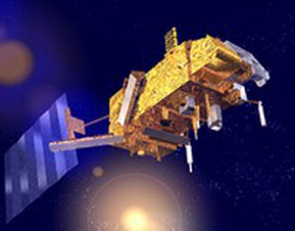
Andrew BurgessMetOp1, a revolutionary state-of-the-art satellite, has just been launched from Baikonur Cosmodrome, Kazakhstan
Marc Cohen, the MetOp Programme Manager at the heart of EUMETSAT, the European organisation of metrological satellites, is delighted. “If all goes well, the MetOp satellite will soon have its head in the clouds. And it will provide us with better weather forecasts and improved methods of monitoring the climate.”
What is MetOp and what is its speciality?
This satellite, like the two that will follow it, will be placed on a polar orbit at an altitude of around 840kms (approx 525 miles). Until now we have only placed satellites on fixed geostationary orbits, such as Meteosat, which monitor the same part of the Earth from an unchanging location above the equator at an altitude of 36,000kms (approx 22,400 miles). By orbiting 42 times closer to the Earth’s surface, MetOp will be able to observe the atmosphere in much greater detail and collect data from all parts of the globe. Boasting a lifespan of 5 years, the spacecraft will take only 100 minutes to fulfill a complete orbit of the Earth and will make this journey 14 times a day passing over the poles.
On board, its twelve instruments will feed back high resolution image profiles of global temperature and humidity as well as land-surface and sea-surface temperatures on a global scale. They will also measure the concentration levels of ozone in the atmosphere and monitor air flow over the oceans. But the speciality of the MetOp satellite is its IASI (Infrared Atmospheric Sounding Interferometer), a unique tool, which will considerably improve the accuracy of the data it collects. Over the last 15 years, our research has enabled us to forecast the weather five days in advance (compared to one day in 1991). Within three years we’ll gain another half a day thanks to IASI technology.
How much has this cost, and who is paying?
The MetOp programme, including the construction of the satellites, the infrastructure on the ground and the launching of the three satellites over a period of 14 years, has cost 2,4 million Euros (£1.6m), of which 1,8 million Euros (£1.2m) was put forward by EUMETSAT. As a result the project will cost each European citizen 60 cents (40p) per year. It is the largest ever metrological satellite built in Europe: each satellite weighs almost 4.5 tonnes.
The data that will be relayed back in real time by MetOp will provide information not only to meteorologists but also to scientists around the world who are working on climate change. The most accurate weather forecasts and climate surveillance are expected.
Was MetOp constructed in collaboration with the United States of America? Is Europe therefore not capable of innovating alone?
Since the 1980s, Europe and the United States of America have gathered meteorological data in close collaboration. So consequently the twelve instruments on board the MetOp satellites have been developed by CNES (the French Space Agency) in collaboration with the NOAA (National Oceanic and Atmospheric Administration). Today, Europe is asserting herself: the initial ground tests on the satellite show that MetOp will be far more capable than America’s current and future weather satellites. The scatterometre, ASCAT, for example, will allow scientists to measure wind speeds over the oceans with unrivalled precision.
Why was the launch, initially planned for the 17th July, reported?
Three days before, the countdown on the Soyuz launcher that will put MetOp on orbit, was stopped due to some minor technical problems. The launching process is very complex and this type of incident is not uncommon: the launching of the Ariane rocket was on numerous occasions reported such in a similar fashion. In this case, the Soyuz launcher’s ground system – the same which launched Gagarin into space – was defective. The rocket’s autopilot system, which is now digitalized and no longer analogue, raised a few false alarms during control procedures.
After MetOp, the ocean observer Jason-2 will be launched in 2008
 From our journalist in Usingen, Clea Caulcutt
Galactic gander with Jason-2
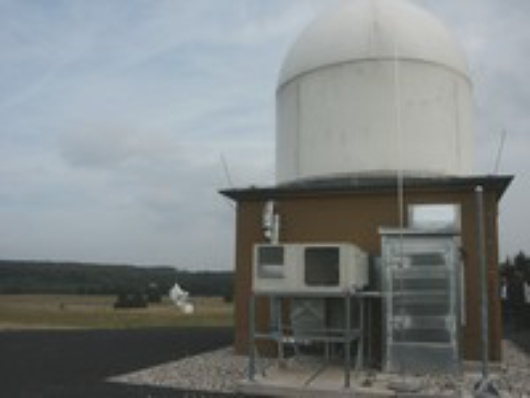
On September 28, top European scientists gathered in the countryside to inaugurate the new Jason-2 earth station
The bus lurches and comes to a stop on the edge of the Usingen ground station. Around us the flat German countryside stretches out ad infinitum. Nothing, or next to nothing can be seen. Unenthusiastic Cameramen and local journalists clamber out of the bus clumsily with their kit balanced on their shoulders. Slowly, we are directed down a pebbled path towards the site of the Jason-2 earth station.
Celestial dialogue
Named after the mythological hero, Jason-2 will circle the earth scanning the surfaces of the oceans, measuring the variations of sea levels and wave heights. In June 2008, the satellite will be launched and take over from his predecessor Jason-1. Jason-2 will provide better warnings and prepare citizens to face natural disasters such as the Tsunami or Hurricane Katrina.
Here in Usingen, a quaint German town north of Frankfurt, the earth station will receive data from Jason-2. But why Usingen? I wonder starring around at the non-descript countryside. I’m told the site was chosen because it had no outstanding feature. Nothing, neither hill nor church steeple, can interfere with the celestial dialogue between Jason-2 and its terrestrial companion. These are perfect conditions for a long distance relationship that will last five long years. Difficult you’d say, but by intergalactic standards, that’s a mere fling.
Drain pipes and global warming
At last, we reach the earth station. Scientists from across Europe cluster around a small mausoleum shaped dome, exchanging jokes about altimetry and algorithms. The major international aerospatiale agencies are represented here, CNES, EUMETSAT, NOAA and NASA, a jungle of Acronyms that leaves me rather puzzled. Dr Rattenborg, EUMETSAT director of operations, and Dr Liebenow, head of technology at T-systems step out of the crowd and place themselves under the fire of the cameramen and photographers. With a certain degree of unease, they hold a rather large key in their hands and wave at their colleagues.
We are quickly invited inside the dome to admire the spinning satellite dish. According to Dr Stetter, Chief Finance Officer for Deutsche Telekom, its construction went very smoothly - except, of course, for a minor bomb alert. Not that aerospatiale scientists have become a new target for international terrorists. No, the security team mistook an old drain pipe for an unexploded WWII bomb.
Jason-2 boasts a far greater level of precision. Global warming, climate change and the evolutions of sea currents are a few phenomena it will observe. Over the last ten years, oceans rose by about 35 mm. And sea levels shows no sign of stabilizing. Sobering facts which bring us back to earth.
Story by
Translated from « Cent minutes pour faire le tour de la Terre »